Gunung Mahameru the Great Mountain
2 10 Share TweetOnce an active volcano in Indonesia, Semeru is an integral part of the volcanic belt of Asia called, the “Pacific Ring of Fire”. It is located in East Java and is 3,676 metres high. This “stratovolcano” is also known as Gunung Mahameru (the Great Mountain) due to its supreme attributes. In fact, Mahameru actually refers to the Hindu god Siwa in local dialects. Siwa the Destroyer (Dewa Pemusnah) is the most powerful one, hence, it comes to no surprise that Mount Semeru is named after this forceful deity.

This mountain is situated between the administration and Lumajang Malang Regency and has a geographic position between 8 ° 06 ‘S and 120 ° 55’ E.
According to old folks, the island of Java used to be in an unstable condition. For that reason, the gods moved Mahameru – a great mountain in India to Java. During the journey, the mountain’s rim rippled and fell on the ground thus creating the mountain belt across Sumatra to Eastern Java. This belt includes Mt. Bukit Barisan in Sumatra, Mt. Krakatau, Mt. Merapi on Middle Java, and Mt. Penanggungan in East Java.
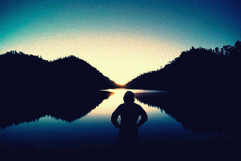
My journey to Mt. Semeru started in Ranu Pane village. It is actually the last village in the Bromo Semeru National Park border. For my climb to Mt. Semeru, I stuffed my bag with 3-days worth of food, even though I did this as a tourist, I was quite comforted by the fact that I was going with two friends, who also happen to be professional mountaineers. We headed out early in the morning, the path that we took was actually decent, I’m guessing that based on its condition, its a common path for tourists and mountaineers. It took me about five hours to go through the 9km path and onto our first post, Ranu Kumbolo, “ranu” means lake and it is a refreshing sight to behold after all that trekking. Make sure to fill up your water tank here since it’s going to be hard to get water further on your journey. We set up camp in Ranu Kumbolo; here you can find a climbing hut, and the lake which gives you a wonderful scenery especially in the morning when you happen to catch the sunrise. There are also a lot of fish in the area, sometimes even wild geese. Ranu Kumbolo has an altitude of 2400 metres with an area of 14 has.
After getting enough rest and some lunch, we continued on with our journey to our second post, Kalimati – which means, dead river. Its form looks like a long, narrow valley. This is actually your last chance to load up on water. At the end of Kalimati is where you can find a water source called Sumbermani, but in order reach it you need to walk about a full hour (round trip). The track from Ranu Kumbolo to Kalimati is a dusty savanna on a flat landscape.
From Kalimati we were then on our way to Arcopodo, the last stable ground on Semeru’s Peak. After a couple of hours of walking on the hilly track we again, set up camp. Although that was quite challenging as the ground is not so flat in this area. Further into the Pine forest, you can find birds, sometimes deers, even tigers – although it is also believed that the Java tiger is already extinct. This area is called Cemoro Cage.

We departed at 2am or so – not sure because I was still sleepy at that time. The track is made of unstable, slippery sand, with about 45degrees on elevation. This is the hardest track of all because you tend to keep on slipping. Thankfully, we were able to make it right on time and reached the peak by sunrise. And all I can say is, ‘Wooooooaaaaahhh…’ All the sacrifices that we made to reach the peak were definitely well worth it.
Le magnifique! You’re bound to have an awesome experience, I guarantee that.


geschrieben von specialblewah am 2010-12-03 in #Orte #travel #camp #indonesia #national-park #location #malang #travel-destination #east-java


2 Kommentare